

Browse Items (35717 total)
Sort by:
Woman and Two Girls

Unidentified woman wearing a large hat and ankle-length dress is standing beside two unidentified little girls, both wearing hats and holding garden tools.
Probably this was a mother with her two daughters.
Probably this was a mother with her two daughters.
Woman and Two Girls

Portrait photograph of an unidentified woman wearing a necklace and shown with two unidentified girls, of different ages.
Probably, this was a mother and her two daughters.
Probably, this was a mother and her two daughters.
Woman and Two Girls

Undentified woman, seated, with two unidentified girls standing on either side of her.
Probably, this was a family photograph.
Probably, this was a family photograph.
Woman and Two Girls

Unidentified woman in glasses with her hair parted in the middle, is seated on a bench with an unidentified young girl on either side of her.
Probably, this was a family group.
Probably, this was a family group.
Woman and Two Girls

Unidentified woman with her hair pulled up is seated with her arms around unidentified girls with bows in their hair.
Probably, this was a family photograph.
Probably, this was a family photograph.
Woman and Two Girls
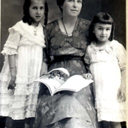
Photo of a photograph of an unidentified woman, seated with an open book on her lap, and flanked by two unidentified young girls.
Possibly, this was a mother and her children.
Possibly, this was a mother and her children.
Woman and Two Girls
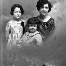
Portrait photograph of an unidentified woman with short hair posed with two unidentified girls of different ages, both wearing print dresses.
Probably, this was a mother and her children.
Probably, this was a mother and her children.
Woman and Two Men

Photograph of an unidentified woman seated between two unidentified men, possibly teenagers.
This may be a family photograph.
This may be a family photograph.
Woman and Two Young Children

Unidentified woman wearing a hat, is seated on a bench with an unidentified young child on her lap and a girl seated beside her.
Probably this was a mother and her two children.
Probably this was a mother and her two children.
Woman and Two Young Children

Unidentified woman with short wavy hair is seated on a bench with her arm around a little boy on one side and a baby posed beside her on the other side.
Probably, this was a family group.
Probably, this was a family group.
Woman and Two Young Children
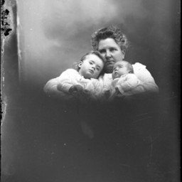
Portrait photograph of an unidentified woman with short, styled hair holding a young child and a baby in her arms.
Probably, this was a family group.
Probably, this was a family group.
Woman and Two Young Children
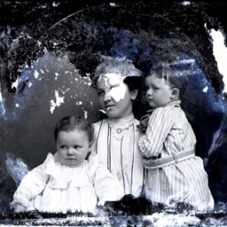
Unidentified woman in a striped blouse is posed with a young child on either side of her.
Probably, this was a mother with her two children.
Significant emulsion damage to the glass plate has obliterated the top of the image including some of…
Probably, this was a mother with her two children.
Significant emulsion damage to the glass plate has obliterated the top of the image including some of…
Woman and U.S. Army Soldier

Photo of a photograph of an unidentified soldier in a U.S. Army uniform standing beside an unidentified older woman, possibly his mother.
The image is taken outdoors and two vintage cars are visible behind them.
The date, "4-28-43" is written…
The image is taken outdoors and two vintage cars are visible behind them.
The date, "4-28-43" is written…
Woman and Umbrella

Photo of a photograph of an unidentified woman holding an open umbrella above her head and wearing a wide-brimmed hat.
Woman And Vase of Flowers

Unidentified woman shown next to a large basket or vase of flowers.
Woman and Vintage Automobile

Unidentified woman with short hair and wearing a print dress, is standing outdoors with an elbow resting on the open window of a vintage automobile.
Woman and Violin

Unidentified young woman with short, curly hair and holding a violin and bow.
Woman and Whited Out Girl

Photo of a portrait photograph of an unidentified woman with her hair pulled back and wearing a pin at the neck of her dress.
The image of a young girl has been whited out.
Probably, the photographer was preparing to make a new image of the…
The image of a young girl has been whited out.
Probably, the photographer was preparing to make a new image of the…
Woman and Young Boy

Unidentified woman with part of the image of an unidentified young boy visible beside her.
The woman is wearing a high neck collar with a cameo brooch. A person's face is visible on the cameo pin.
The woman is wearing a high neck collar with a cameo brooch. A person's face is visible on the cameo pin.
Woman and Young Child

Unidentified woman wearing a winter coat and hat is holding a toddler on her lap.
Woman and Young Child

Unidentified woman, seated, and holding an unidentified barefoot young child on her lap.
Woman and Young Child

Unidentified woman is seated on a bench and holding an unidentified young child in her arms.
Probably, this was a mother and her child.
Probably, this was a mother and her child.
Woman and Young Child

Unidentified elderly woman is seated on a wicker bench with a young unidentified girl with short hair and bangs standing beside her.
Probably, these two were related.
Probably, these two were related.
Woman and Young Child

Unidentified young woman is seated on a bench and looking down at the unidentified baby on her lap.
Probably, this was a mother and her child.
Probably, this was a mother and her child.
Woman and Young Child

Portrait photograph of an unidentified woman with glasses posed with an unidentified young child with bangs.