

Browse Items (15 total)
Sort by:
View of Seven Bends
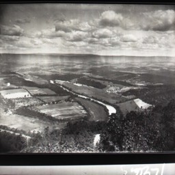
View looking southwest across the Seven Bends area of the North Fork of the Shenandoah River near Woodstock.
View of Seven Bends
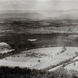
View of the Shenandoah Valley taken from above the area of the Shenandoah River known as Seven Bends and looking west towards the town of Woodstock and the mountains beyond it.
Shenandoah River Landscape

Photograph showing a view of the Shenandoah River near Woodstock.
The area visible was the "Bowman-Williams" Farm at the time of the photograph. As of 2025, it was home to the Lesiure Point subdivision adjacent to Woodstock Tower Road.
The…
The area visible was the "Bowman-Williams" Farm at the time of the photograph. As of 2025, it was home to the Lesiure Point subdivision adjacent to Woodstock Tower Road.
The…
Seven Bends of the Shenandoah, near Woodstock, Virginia

Color postcard showing a picture of the Seven Bends of the Shenandoah River as seen from the Massanutten Mountain west of Woodstock Virginia.
A Matchless Scene of Beautiful Shenandoah Valley, VA

Color postcard showing the Seven Bends of the Shenandoah River located near Woodstock Virginia.
View from Massanutten Mountain Looking West Showing Shenandoah River and Woodstock, VA

Color postcard showing a picture of the Seven Bends of the Shenandoah River and Woodstock Virginia from the Massanutten Mountain.
View of Shenandoah River and Valley, Woodstock in the distance

Color postcard showing the Seven Bends of the Shenandoah River and the Shenandoah Valley from the Massanutten Mountain located just west of Woodstock Virginia.
The Seven Bends of the Shenandoah RIver and Shenandoah Valley, Virginia

Color postcard bearing an image of the famed Seven Bends of the Shenandoah River. Photograph taken from the area of the Woodstock Tower facing west.
The photograph was produced in 1939 by the Asheville Postcard Company.
The photograph was produced in 1939 by the Asheville Postcard Company.
Panorama of Shenandoah Valley

Postcard with a picture and description of the Seven Bends of the Shenandoah River located just west of Woodstock Virginia.
Panorama of Shenandoah Valley

Postcard with a picture and description of the Seven Bends of the Shenandoah River located just west of Woodstock Virginia.
The Seven Bends of the Shenandoah River and Shenandoah Valley, Virginia

Color postcard showing the Seven Bends of the Shenandoah River located just west of Woodstock Virginia.
The Shenandoah, Woodstock Va., in the distance and some of the horseshoe bend in the river.

Color postcard with a picture of the Shenandoah River and part of the seven bends with Woodstock in the background. Taken from the Massanutten Mountain west of town.
Beautiful Shenandoah River and Valley from Massanutten Mountain, Woodstock VA

Color Postcard showing the part of the Seven Bends of the Shenandoah River and the Shenandoah Valley near Woodstock Virginia. Take from the Massanutten Mountain.
Seven Bends of the Shenandoah

Color postcard with a picture of the Seven Bends of the Shenandoah River located east of Woodstock Virginia.
Shenandoah River at Woodstock, Virginia

Postcard with an image showing the North Fork of the Shenandoah River near Woodstock Virginia.
The exact location of this scene is undetermined, but would be east of the town.
The postcard is undated but includes a description of the image.
The exact location of this scene is undetermined, but would be east of the town.
The postcard is undated but includes a description of the image.