

Browse Items (46 total)
Sort by:
Bridge at Burnshire Dam
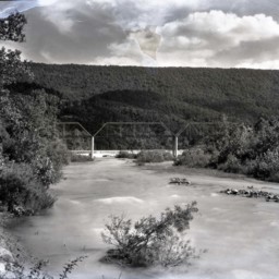
Photograph of the bridge spanning the Shenandoah River northwest of Woodstock Virginia. Behind it is Burnshire Dam and the mountains.
Originally, this site was home to Rush's Mill. In 1873 it was purchased by J.I. Triplett. In 1892 he converted…
Originally, this site was home to Rush's Mill. In 1873 it was purchased by J.I. Triplett. In 1892 he converted…
Shenandoah River at Camp Lupton
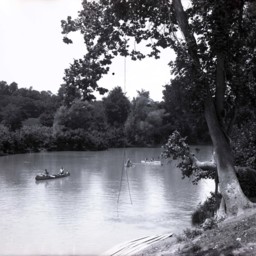
Unidentified campers in canoes are seen floating on the Shenandoah River at Camp Lupton Boys Camp.
A swing is also visible hanging down from the tree in the foreground.
Camp Lupton was part of the Massanutten Military Academy (MMA) for many…
A swing is also visible hanging down from the tree in the foreground.
Camp Lupton was part of the Massanutten Military Academy (MMA) for many…
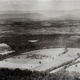
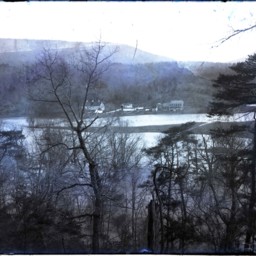
View of Seven Bends
View looking southwest across the Seven Bends area of the North Fork of the Shenandoah River near Woodstock.
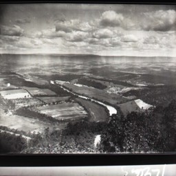
View of Seven Bends
View of the Shenandoah Valley taken from above the area of the Shenandoah River known as Seven Bends and looking west towards the town of Woodstock and the mountains beyond it.
Hollingsworth Ford Near Woodstock
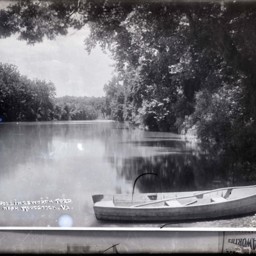
Photo of a photograph of an area of the North Fork of the Shenandoah River known as Hollingsworth Ford.
A small boat is visible in the foreground.
The image is labeled, "Hollingsworth Ford Near Woodstock, Va".
Today this is the site of a…
A small boat is visible in the foreground.
The image is labeled, "Hollingsworth Ford Near Woodstock, Va".
Today this is the site of a…
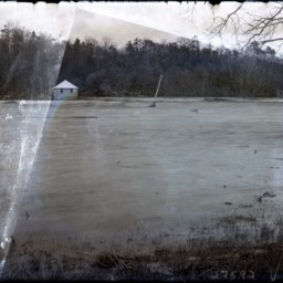
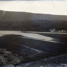
Flooded Area
Photograph of a flooded farm field.
A barn, house, and other structures are visible in the picture.
The location of this site is unknown, but it may be near Woodstock Virginia.
A barn, house, and other structures are visible in the picture.
The location of this site is unknown, but it may be near Woodstock Virginia.
Flooded River and Dam
Photograph showing an unidentified flooded river (most likely the Shenandoah River).
A power house and flooded dam spanning the river are visible.
A power house and flooded dam spanning the river are visible.
Flooded Area
Photograph showing an unidentified flooded river (most likely the Shenandoah River).
A power house and flooded dam spanning the river are visible.
A power house and flooded dam spanning the river are visible.
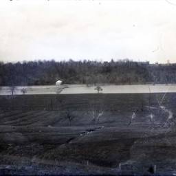
Flooded Area Near Burnshire Dam
Photograph of a flooded farm field.
A barn, house, and other structures are visible in the picture.
The location of this site is unknown, but it may be near Woodstock Virginia.
A barn, house, and other structures are visible in the picture.
The location of this site is unknown, but it may be near Woodstock Virginia.
Shenandoah River Near Brock's Gap

View of the North Fork of the Shenandoah River as it flows towards Brock's Gap in Broadway, Virginia.
A dirt road, truck, and electric lines are visible on the left side.
A dirt road, truck, and electric lines are visible on the left side.
View of Riverton

Photograph showing the community of Riverton and the Shenandoah River near Front Royal in Warren County Virginia. Chester Gap is visible in the background.
The photograph looks south. The road and bridge visible are part of the “Winchester…
The photograph looks south. The road and bridge visible are part of the “Winchester…
Shenandoah River and Stricklers Knob

Photograph showing the Shenandoah River and Strickler's Knob in Page County near Luray Virginia.
Shenandoah River near Riverton

Photograph showing the concrete dam spanning the Shenandoah River near the community of Riverton in Warren County Virginia.
Riverton is visible on the left of the image.
Riverton is visible on the left of the image.
People on the Shenandoah River

Photo of an older photograph of a group of unidentified boys in a canoe on the edge of what appears to be the Shenandoah River. The unidentified man on the left is holding a long pole that may have been used to propel the boat.
Stout Farm

Photo of a photograph of the "Stout Farm" (local name based on the family that was associated with the farm for many years) with a house, barn, and multiple other buildings. The Shenandoah River is in the foreground and the Massanutten Mountain is in…
Railroad Bridge and Signal Knob, Near Strasburg

Photograph of the Shenandoah River, railroad bridge. and Massanutten Mountain's Signal Knob near Strasburg Virginia.
The photograph was taken from the Route 55 Highway bridge just east of Strasburg.
The photograph was taken from the Route 55 Highway bridge just east of Strasburg.
Fishing Party on the Shenandoah River, near Luray Va.

Postcard showing a fishing part on the Shenandoah River near Luray Virginia
View of Shenandoah River as seen from Shenandoah River Lodge

Postcard showing the Shenandoah River lodge located near Luray Virginia
Shenandoah River & Massanutton Mountain

Postcard showing the Shenandoah River and "Massanutton" Mountain near Luray
Golden Rock and Shenandoah River Near Compton Virginia

Postcard showing Golden Rock and the Shenandoah River near Compton in Page County Virginia
Indian Rock Luray Va

Postcard showing the Indian Rock along the Shenandoah River near Luray Virginia
Shenandoah River and Strickler's Knob Near Luray VA

Postcard showing the Shenandoah River and Strickler's Knob in the background. Includes description of the Knob and local landmarks.
Scene on the North Fork of the Shenandoah, near New Market, Va.

Postcard showing the North Fork of the Shenandoah River near New Market Virginia
The Shenandoah in Brock's Gap, Va.

Postcard showing the Shenandoah River near Brocks Gap in Rockingham County Virginia
Shenandoah River, New Market, VA

Postcard showing the Shenandoah River near New Market Virginia. Includes description of the river and its history.