

Browse Items (35719 total)
Sort by:
Plains District Horse Show

Photograph taken by William Hoyle Garber showing three women with awards at the Plains District Horse Show held in Timberville Virginia in July 11, 1949. The women are, from left to right: Ruth Pence, Geraldine Hoover, and Eleanor Williams.
Plains District Horse Show

Photograph taken by William Hoyle Garber showing five unidentified men, an unidentified woman, and an unidentified girl at the Plains District Horse Show held in Timberville Virginia on July 11 1947.
Plains District Horse Show

Photograph taken by William Hoyle Garber showing three women with awards at the Plains District Horse Show held in Timberville Virginia in July 11, 1949. The women are, from left to right: Bonnie Fay Gordon, Evelyn Clem, and Creeola Kline.
Plains District Horse Show

Photograph taken by William Hoyle Garber showing three unidentified women with awards at the Plains District Horse Show held in Timberville Virginia in July 11, 1949.
Plains District Horse Show

Photograph taken by William Hoyle Garber showing the Plains District horse Show held in Timberville Virginia on July 11, 1948.
Pictured are, from left to right: Howard Zigler, Elizabeth hite, and Clay Post.
Pictured are, from left to right: Howard Zigler, Elizabeth hite, and Clay Post.
Plains District Horse Show

Photograph taken by William Hoyle Garber showing three women at the Plains District Horse Show held in Timberville Virginia on July 11 1948.
The woman on the right appears to be holding an awards cup. From left to right is: Mary Stuart Rhodes,…
The woman on the right appears to be holding an awards cup. From left to right is: Mary Stuart Rhodes,…
Plains District Horse Show

Photograph taken by William Hoyle Garber showing two unidentified men and three unidentified women at the Plains District Horse Show held in Timberville Virginia on July 11, 1948.
The rider appears to have won an award that was presented to him…
The rider appears to have won an award that was presented to him…
Plains District Horse Show

Photograph taken by William Hoyle Garber showing an unidentified man and three women with a horse at the Plains District Horse Show held in Timberville Virginia on July 11, 1948. The rider appears to have won an award that was presented by the women.…
Plains District Horse Show

Photograph taken by William Hoyle Garber showing a man on a cart and three women at the Plains District Horse show held in Timberville Virginia on July 11 1948.
The man driving the cart is identified as Clay Post. He appears to be receiving an…
The man driving the cart is identified as Clay Post. He appears to be receiving an…
Plains District Horse Show

Photograph taken by William Hoyle Garber showing the Plains District Horse Show, held in Timberville Virginia on July 11 1948.
Pictured is Eleanor Williams, on left, and an unidentified man on horseback.
Pictured is Eleanor Williams, on left, and an unidentified man on horseback.
Plains District Horse Show

Photograph taken by William Hoyle Garber showing two unidentified men and a donkey at the Plains District Horse Show, held in Timberville Virginia on July 11 1948.
Plains District Horse Show

Photograph taken by William Hoyle Garber showing an unidentified clown on a cow at the Plains District Horse Show, held in Timberville Virginia on July 11 1948.
Plains District Horse Show

Photograph taken by William Hoyle Garber showing an unidentified horse and rider at the Plains Distric Horse Show, held in Timberville Virginia, on July 11 1948.
Plains District Horse Show

Photograph taken by William Hoyle Garber showing an unidentified man at the Plains District Horse Show, located in Timberville Virginia, on July 11, 1948.
Pin Up Picture No. 2

Photograph of a drawing labeled "Pin Up Picture No. 2" and showing a female pin up character.
Pile of Gourds

Photograph of different types of gourds of varying sizes stacked upon one another in front of a fence.
Pile of Gourds

Photograph of various squashes, pumpkins, and gourds, piled and posed for the picture.
Pig with Chickens

Photograph of a pig in a barn. There are multiple chickens moving around the pig.
Pig in Profile

Extremely damaged image of a pig in a field outdoors. The pig is shown in profile.
Pierre Ott

Portrait photograph of Pierre Ott in his Massanutten Military Academy (MMA) uniform.
The name, "G. Ott" and the date, "May 16, 1949" were written on the glass plate of this image.
Pierre Ott was a cadet at Massanutten Military Academy in…
The name, "G. Ott" and the date, "May 16, 1949" were written on the glass plate of this image.
Pierre Ott was a cadet at Massanutten Military Academy in…
Piece of Unknown Equipment
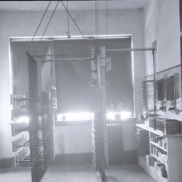
Interior of a room with shelves along one wall, covered windows straight ahead, and an unidentified large structure in the middle of the room.
We are unsure what this piece of equipment was used for.
We are unsure what this piece of equipment was used for.
Picture of the New Emmanuel-St. Matthew's Lutheran Church Under Construction

Postcard showing a drawing of Reformation Lutheran Church, then called Emmanuel-St. Matthew's, while it was under construction. Card was produced to encourage contributions.
Picnic Grounds, Cedar Creek near Strasburg Va.

Postcard showing a picnic grounds along Cedar Creek near Strasburg.
Picnic Celebrates 150 Years of Reconciliation

Article describing events planned for the Fisher's Hill Battlefield Reunion Picnic
Piano Store
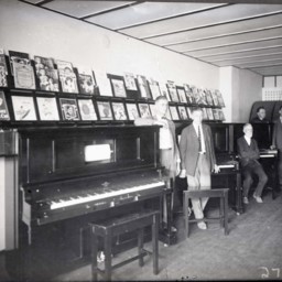
Six unidentified men are standing along a row of upright pianos in a music store.
Rows of sheet music are displayed in two rows above the pianos.
Rows of sheet music are displayed in two rows above the pianos.