

Browse Items (19 total)
Sort by:
Triplett Dam and Powerhouse
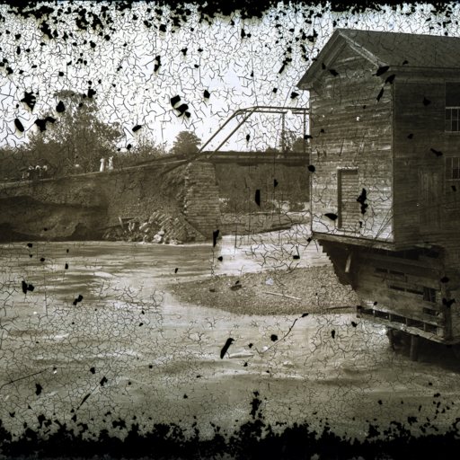
Photograph showing the damaged powerhouse and Triplett dam near Woodstock Virginia following a 1910 flood.
Today the site is home to Burnshire Dam.
This dam was originally the site of Rush's Mill before being purchased by J.I. Triplett in…
Today the site is home to Burnshire Dam.
This dam was originally the site of Rush's Mill before being purchased by J.I. Triplett in…
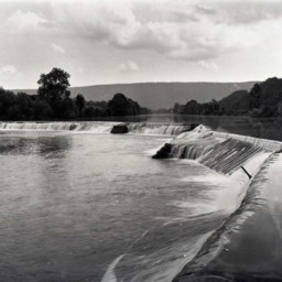
Stonewall Mill Dam on Shenandoah River, Virginia
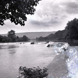
Photograph of Stonewall Dam near Pugh's Run.
This dam was part of the Stonewall Mill complex. The original mill dates to before the Civil War, but this dam was most likely constructed around the turn of the 20th century when the site began…
This dam was part of the Stonewall Mill complex. The original mill dates to before the Civil War, but this dam was most likely constructed around the turn of the 20th century when the site began…
Stonewall Mill Dam on Shenandoah River, Virginia
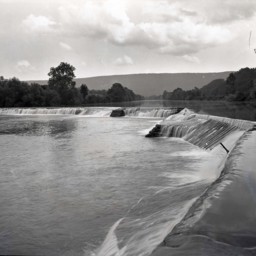
Photograph of Stonewall Dam near Pugh's Run.
This dam was part of the Stonewall Mill complex. The original mill dates to before the Civil War, but this dam was most likely constructed around the turn of the 20th century when the site began…
This dam was part of the Stonewall Mill complex. The original mill dates to before the Civil War, but this dam was most likely constructed around the turn of the 20th century when the site began…
Stonewall Mill Dam on Shenandoah River, Virginia
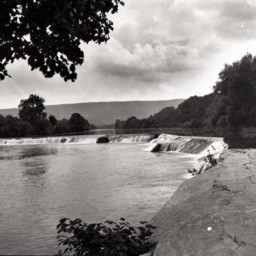
Photo of a photograph of Stonewall Dam near Pugh's Run.
This dam was part of the Stonewall Mill complex. The original mill dates to before the Civil War, but this dam was most likely constructed around the turn of the 20th century when the site…
This dam was part of the Stonewall Mill complex. The original mill dates to before the Civil War, but this dam was most likely constructed around the turn of the 20th century when the site…
Stonewall Mill Dam on Shenandoah River, Virginia
Photograph of Stonewall Dam near Pugh's Run.
This dam was part of the Stonewall Mill complex. The original mill dates to before the Civil War, but this dam was most likely constructed around the turn of the 20th century when the site began…
This dam was part of the Stonewall Mill complex. The original mill dates to before the Civil War, but this dam was most likely constructed around the turn of the 20th century when the site began…
Stonewall Mill Dam on Shenandoah River, Virginia
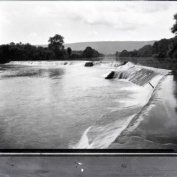
Photo of a photograph of Stonewall Dam near Pugh's Run.
This dam was part of the Stonewall Mill complex. The original mill dates to before the Civil War, but this dam was most likely constructed around the turn of the 20th century when the site…
This dam was part of the Stonewall Mill complex. The original mill dates to before the Civil War, but this dam was most likely constructed around the turn of the 20th century when the site…
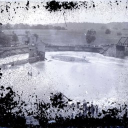
Dynamiting the Triplett Dam - 1910
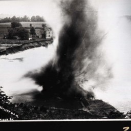
Photo of the photograph taken on June 19, 1910, at the moment the Triplett Dam was dynamited to relieve flooding.
The Triplett Dam spanned the North Fork of the Shenandoah River east of Woodstock.
This dam was originally the site of Rush's Mill…
The Triplett Dam spanned the North Fork of the Shenandoah River east of Woodstock.
This dam was originally the site of Rush's Mill…
Burnshire Dam
Photograph of the dam spanning the Shenandoah River northwest of Woodstock Virginia.
The dam is locally known as Burnshire Dam.
Originally, this site was home to Rush's Mill. In 1873 it was purchased by J.I. Triplett. In 1892 he converted the…
The dam is locally known as Burnshire Dam.
Originally, this site was home to Rush's Mill. In 1873 it was purchased by J.I. Triplett. In 1892 he converted the…
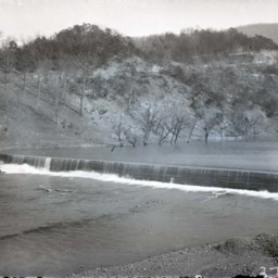
Flooded River and Dam
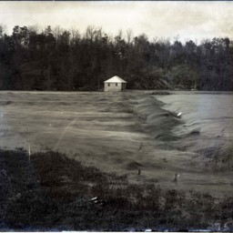
Photograph showing an unidentified flooded river (most likely the Shenandoah River).
A power house and flooded dam spanning the river are visible.
A power house and flooded dam spanning the river are visible.
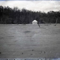
Flooded River and Dam
Photograph showing an unidentified flooded river (most likely the Shenandoah River).
A power house and flooded dam spanning the river are visible.
A power house and flooded dam spanning the river are visible.
Flooded River and Dam
Photograph showing an unidentified flooded river (most likely the Shenandoah River).
A power house and flooded dam spanning the river are visible.
A power house and flooded dam spanning the river are visible.
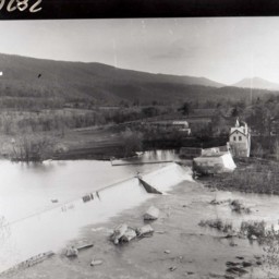
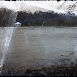
Triplett Dam Near Woodstock
Photograph of the Triplett Dam that spans the North Fork of the Shenandoah River east of Woodstock.
This photograph was taken when the dam was flooded in 1910. During that flood, the dam was dynamitedon June 19, 1910. This photograph was taken…
This photograph was taken when the dam was flooded in 1910. During that flood, the dam was dynamitedon June 19, 1910. This photograph was taken…
Flooding at Burnshire Dam
Photograph of the dam spanning the Shenandoah River northwest of Woodstock Virginia.
The dam is locally known as Burnshire Dam. The river around it appears to be in flood stage.
Originally, this site was home to Rush's Mill. In 1873 it was…
The dam is locally known as Burnshire Dam. The river around it appears to be in flood stage.
Originally, this site was home to Rush's Mill. In 1873 it was…
Woodstock Reservoir

Photograph of the Woodstock Reservoir and Dam located on the Massanutten Mountain.
The reservoir is now part of Seven Bends State Park.
The negative is labeled "Hill Top World's."
The reservoir is now part of Seven Bends State Park.
The negative is labeled "Hill Top World's."
Woodstock Reservoir Dam

Photograph of the dam at the Woodstock Reservoir.
The reservoir is now part of Seven Bends State Park.
The reservoir is now part of Seven Bends State Park.
S.P. Lonas' Mills Dam, Mt. Jackson Va.

Postcard showing the "S.P. Lonas' Mill Dam" in Mt. Jackson Virginia.
The dam was located on Mill Creek on what is now the southern part of town. It was constructed sometime before 1897.
The dam was located on Mill Creek on what is now the southern part of town. It was constructed sometime before 1897.
Stonewall Mill Dam on Shenandoah River, Virginia

Colorized postcard labeled "Stonewall Dam on Shenandoah River, Virginia. - A Scene Near Woodstock Va." It is dated 1937.
This dam was part of the Stonewall Mill complex. The original mill dates to before the Civil War, but this dam was most…
This dam was part of the Stonewall Mill complex. The original mill dates to before the Civil War, but this dam was most…
Shenandoah River from Bridge, Woodstock, Va.

Postcard with a picture of the Shenandoah River and dam taken from the river bridge located just east of Woodstock Virginia. The area is locally known as "Burnshire's."
Stickley's Dam and Massanutten Mountain, Strasburg, Va.

Postcard with a picture of Stickley's Dam near Strasburg Virginia. The dam is located on Cedar Creek. The Massanutten Mountain is visible in the background.