

Browse Items (134 total)
Sort by:
Snarr & Miley Store
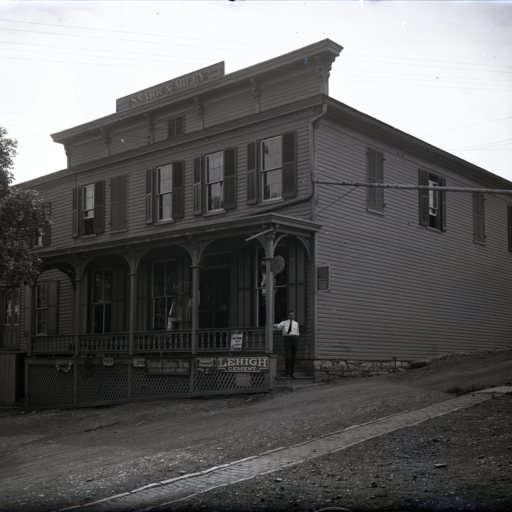
Photograph of the Snarr & Miley Store located in Toms Brook Virginia.
A portion of the building still stands on Hillcrest Drive at the railroad tracks.
A portion of the building still stands on Hillcrest Drive at the railroad tracks.
Buildings Under Construction at Endless Caverns
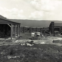
Photograph of two buildings being constructed at the Endless Caverns resort in New Market, Virginia.
Various pieces of construction equipment are seen in the yard between the two stone buildings.
Various pieces of construction equipment are seen in the yard between the two stone buildings.
Buildings Under Construction at Endless Caverns
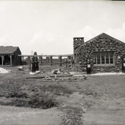
Photograph of two buildings being constructed at the Endless Caverns resort in New Market, Virginia.
Gas pumps have been installed and the building on the left has a covered porch.
Gas pumps have been installed and the building on the left has a covered porch.
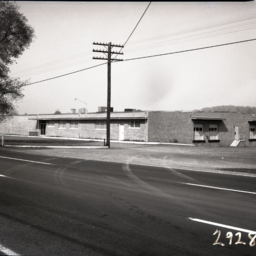
Fairground Road Looking East
View taken from Old Route 42 (now called Fairground Road) in Woodstock, Virginia.
The image is looking east towards Grabill's Manufacturing Plant visible in the background.
In 2013, the site was used by Shaffer's.
The image is looking east towards Grabill's Manufacturing Plant visible in the background.
In 2013, the site was used by Shaffer's.
Man Holding a Chicken
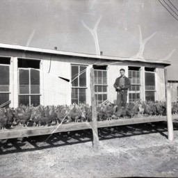
Unidentified man is standing outside of a chicken house and holding a chicken. Other chickens are all around him.
This photograph was probably taken at the site of "Shaffer's Chicks", an egg hatchery business.
This photograph was probably taken at the site of "Shaffer's Chicks", an egg hatchery business.
Chicken Houses and Chickens
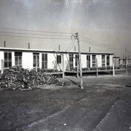
Photograph of a row of chicken houses with a pile of firewood in front of them.
Many chickens are visible in fenced enclosures in front of the chicken houses.
Many chickens are visible in fenced enclosures in front of the chicken houses.
Casey Jones Plant and Employees
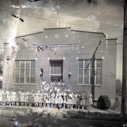
Photograph of a large group of unidentified women assembled outside the Casey Jones Clothing Factory that was located on East Court Street in Woodstock.
The Maryland Company began in the 1920's and, expanded to include plants in Woodstock, Mount…
The Maryland Company began in the 1920's and, expanded to include plants in Woodstock, Mount…
Field of Turkeys
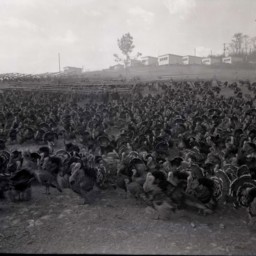
Photograph of thousands of turkeys on a field.
Four unidentified men are standing behind them in the center of the image.
Behind the men and up the hill are several buildings.
Four unidentified men are standing behind them in the center of the image.
Behind the men and up the hill are several buildings.
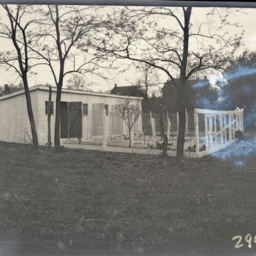
Smoot Trailer Park, Mount Jackson Virginia.
Photograph showing the entrance to the "Smoot Trailer" Park in Mount Jackson Virginia.
The park is located in the southern part of town on Smoot Trailer Park Road.
The photograph looks east showing US Route 11 in the distance with several…
The park is located in the southern part of town on Smoot Trailer Park Road.
The photograph looks east showing US Route 11 in the distance with several…
Barn Interior
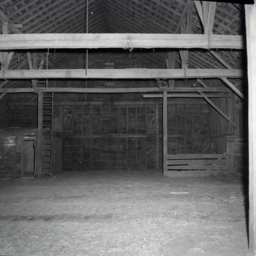
Photograph of the interior of a large barn.
This barn was originally located on S. Middle Road just west of Bowmans Crossing. During the construction of Interstate 81 it was relocated to behind 13460 S. Middle Road to make way for the 277…
This barn was originally located on S. Middle Road just west of Bowmans Crossing. During the construction of Interstate 81 it was relocated to behind 13460 S. Middle Road to make way for the 277…
Hole in the Roof
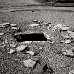
Photograph of a square hole purposefully cut into the flat roof of an unidentified building.
A stream is visible at the top of the image.
The photograph was produced as part of a forensic investigation.
A stream is visible at the top of the image.
The photograph was produced as part of a forensic investigation.
View of Riddleberger and Lantz Halls
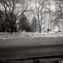
Photograph taken from Route 11 (Main Street) in Woodstock looking west across the stone wall that marks the edge of Massanutten Military Academy's campus in Woodstock.
Two buildings are visible. On the right is Riddleberger Hall.
It was the…
Two buildings are visible. On the right is Riddleberger Hall.
It was the…
Woodstock Recreation Park
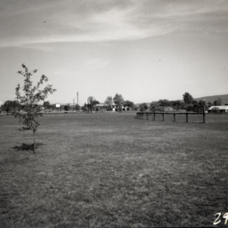
Photograph showing the Woodstock Recreation Park, now W.O. Reiley Park.
Visible is the pool building, tennis court, and originally installed fighter jet playground.
Visible is the pool building, tennis court, and originally installed fighter jet playground.
View of Riddleberger and Lantz Halls
Photograph taken from Route 11 (Main Street) in Woodstock looking west across the stone wall that marks the edge of Massanutten Military Academy's campus in Woodstock.
Two buildings are visible. On the right is Riddleberger Hall.
It was the…
Two buildings are visible. On the right is Riddleberger Hall.
It was the…
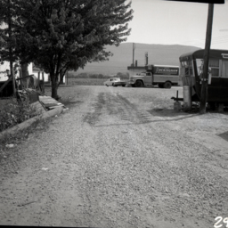
Smoot Trailer Park, Mount Jackson Virginia.
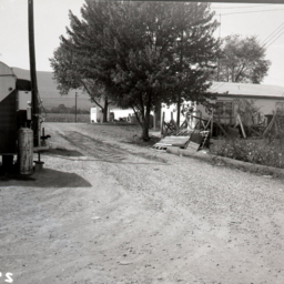
Photograph of the area behind a small business.
Part of a trailer is visible on the right and the business is on the left. The word, "ICE" is visible on a stand alone cooler.
A shade tree is in the center of the image.
Part of a trailer is visible on the right and the business is on the left. The word, "ICE" is visible on a stand alone cooler.
A shade tree is in the center of the image.
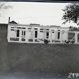
Hen House and Turkeys
Photograph of a large hen house with multiple doors leading from the fenced area into the building.
Chickens are visible in the fenced enclosure and there are turkeys walking by on the outside of the fence.
Chickens are visible in the fenced enclosure and there are turkeys walking by on the outside of the fence.
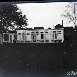
Hen House
Photograph of a large hen house with multiple doors leading from the fenced area into the building.
Chickens are visible in the yard.
Chickens are visible in the yard.
Irvin Inc. Building - Edinburg
Photograph of the building that housed Irvin Inc., a wholesale distribution facility also known as the Irvin Candy Company.
Irvin Incorporated was established by George E. Irvin, and his business partner, J.I. Triplett, in 1884, as a farm…
Irvin Incorporated was established by George E. Irvin, and his business partner, J.I. Triplett, in 1884, as a farm…
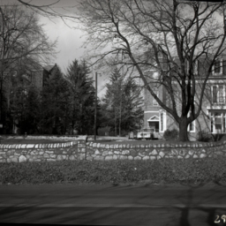
Lantz Hall, MMA, Woodstock
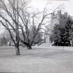
Winter view of the lawn, with two large trees, in front of Lantz Hall on the campus of Massanutten Military Academy (MMA) in Woodstock, Virginia.
Three Vintage Airplanes
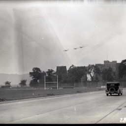
View of three vintage bi-planes flying over unidentified stone buildings and beyond an athletic field.
A road and early automobile are on the right side of the image.
A road and early automobile are on the right side of the image.
Woodstock Fire Department
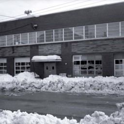
Photograph of the Woodstock Fire station on Court Street in Woodstock while it was under construction.
There is snow on the ground.
There is snow on the ground.
Miller's Lunch in Woodstock
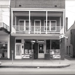
Photograph of the two-story brick building on Main Street in Woodstock that housed the Miller Lunch business. Advertisements in the window are for Newport and Chesterfield cigarettes. Coca Cola signs are also visible.
The space was later used as…
The space was later used as…
View of Liberty Iron Furnace
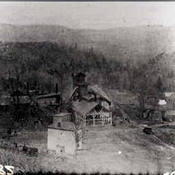
Photo of a photograph of buildings that were part of the Liberty Iron Furnace.
Liberty Furnace was located along Stony Creek approximately 11 miles west of Edinburg, Virginia.
Liberty Furnace was located along Stony Creek approximately 11 miles west of Edinburg, Virginia.
Liberty Iron Furnace
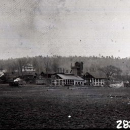
Photograph of Liberty Iron Furnace, located along Stony Creek approximately 11 miles west of Edinburg Virginia.
The superintendent's house (still standing in 2025) is visible on the upper left of the image and the furnace structures are visible…
The superintendent's house (still standing in 2025) is visible on the upper left of the image and the furnace structures are visible…