

Browse Items (97 total)
Sort by:
Mabel Runion

Mabel Runion spent most of her life in the Lantz Mill’s community. Her and her husband Peter moved there in 1938 after living for a few years in the Fairview Community.
The Runions were known for the wide array of animals that lived on their farm.…
The Runions were known for the wide array of animals that lived on their farm.…
Betty Showman
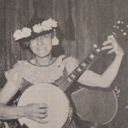
If you had attended a community event in the 70s, or 80s you might have found Betty Showman there, dressed as the popular TV character Minnie Pearl.
A resident of Conicville, Betty began performing as Minnie in 1963. She took her act to various…
A resident of Conicville, Betty began performing as Minnie in 1963. She took her act to various…
Farm Scene

Photograph taken by William Hoyle Garber showing tractors participating in the corn harvest at an unidentified farm.
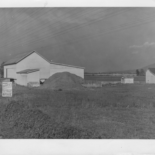
Unidentified Farm

Photograph taken by William Hoyle Garber showing an unidentified farm.
Unidentified Farm

Photograph taken by William Hoyle Garber showing an unidentified farm.
Women at Vehrencamps Grand Opening

Photograph taken by William Hoyle Garber showing a group of women with a refreshment table at the Grand Opening event for Vehrencamps, which sold tractors and farm implements from their location on the north end of Mt. Jackson Virginia.
The women…
The women…
Tisinger Farm
Photograph taken by William Hoyle Garber showing the Tisinger Farm located just south of Mt. Jackson Virginia on US Route 11.
Unidentified Farm

Photograph taken by William Hoyle Garber showing an aerial image of an unidentified farm.
Loading Express, Oct. 1914
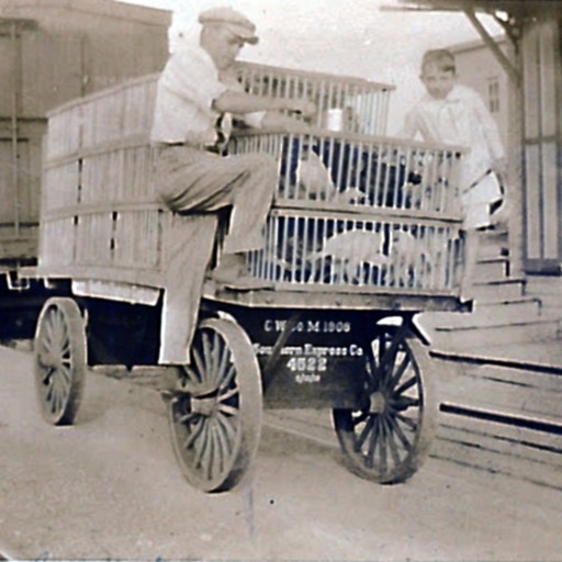
Photograph showing two boys on a Southern Railway Express Company loading wagon filled with chickens.
The photograph is dated October 1914. The boys are unidentified. Most likely the image was taken at the Toms Brook railroad depot, but that…
The photograph is dated October 1914. The boys are unidentified. Most likely the image was taken at the Toms Brook railroad depot, but that…
Ford and Cooley Dairy Bottle Cap

This picture shows a paper milk-bottle cap produced by Woodstock Virginia’s Ford-Cooley Dairy. The dairy was located just south of Woodstock near Narrow Passage. It operated from sometime in the 1930s until around 1960.
It would have been used…
It would have been used…
Riverlawn Farm

Postcard showing the River Lawn Farm house located approximately three miles from New Market Virginia
Scene in Shenandoah Valley, New Market, Virginia

Postcard showing individuals loading hay onto horse drawn wagons near New Market Virginia.
The card is undated and has been colorized.
The card is undated and has been colorized.
"Meem's Bottom" on Route 11 along the Scenic Shenandoah Valley, Va.

Postcard showing US Route 11 passing through "Meem's Bottom."
The view looks north from the area of Rude's Hill, a geographic feature located between Mt. Jackson and New Market. The house and barn on the left of the image still stand (as of 2023)…
The view looks north from the area of Rude's Hill, a geographic feature located between Mt. Jackson and New Market. The house and barn on the left of the image still stand (as of 2023)…
Mt. Airy Farm

Postcard showing the Mt. Airy Farm located at Meems Bottom near Mt. Jackson Virginia.
B.E. Nelson Wheat Field

Postcard showing B.E. Nelson's wheat field.
Seeding on Meems Bottom (Strathmore)

Postcard showing a crew of men with a team of horses and mules seeding farmland.
The card's caption identifies the farm as "Mount Airy (Strathmore)" which is located south of the Town of Mount Jackson along what is now US Route 11 and the North…
The card's caption identifies the farm as "Mount Airy (Strathmore)" which is located south of the Town of Mount Jackson along what is now US Route 11 and the North…
Driveway from Valley Pike to Mt. Airy

Photographic postcard showing the driveway leading to "Mt. Airy" a farm along the Shenandoah River in the Meems Bottom area just south of Mt. Jackson Virginia.
The image also shows the Massanutten Mountain in the background and was taken near…
The image also shows the Massanutten Mountain in the background and was taken near…
Shenandoah Valley Harvest Scene

Postcard with a photograph of men and horses in a "harvest scene" in the Shenandoah Valley.
It includes a caption with information from the valley's history.
It includes a caption with information from the valley's history.
Entrance to Edinburg Snake and Alligator Farm

Postcard with a picture showing a man holding a snake in front of the entrance to the Edinburg Snake and Alligator Farm located in Bowman's Crossing.
Unidentified Farm

Postcard with a picture of an unidentified farm, house, and barn in Shenandoah County.
The Picturesque Shenandoah River with Fishers Hill Battle Ground in the Distance, near Strasburg Va.

Postcard with an image of the Shenandoah River and US Highway 11 near Fishers Hill.
The view looks north toward Strasburg Virginia. The card was produced in 1911.
The view looks north toward Strasburg Virginia. The card was produced in 1911.
Old Virginia Corn Field near Strasburg Va.

Postcard with a picture of a corn field located along the Shenandoah River near Strasburg Virginia.