

Browse Items (35719 total)
Sort by:
Row of Dolls

Photograph of a row of seven dolls, all of which are wearing aprons, floor-length dresses, and head coverings.
Two portray African American faces.
Two portray African American faces.
Row crop production up in Virginia in 1998

Article about an increase in row crop acreage in Virginia
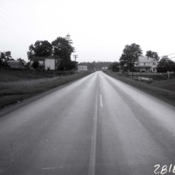
Route 55 East of Strasburg
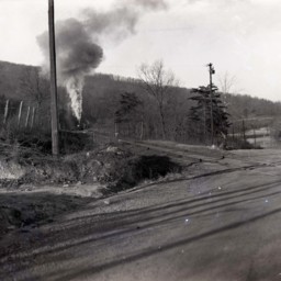
Photograph showing a portion of US Route 55.
This portion is located east of Strasburg Virginia near the foot of the Massanutten Mountain. The road was later rerouted to avoid the railroad crossing pictured here.
A steam engine is headed…
This portion is located east of Strasburg Virginia near the foot of the Massanutten Mountain. The road was later rerouted to avoid the railroad crossing pictured here.
A steam engine is headed…
Route 55 East of Strasburg

Photograph showing a portion of US Route 55 under construction.
This portion is located east of Strasburg Virginia near the foot of the Massanutten Mountain.
A sign straight ahead indicates with an arrow that traffic should use the old road…
This portion is located east of Strasburg Virginia near the foot of the Massanutten Mountain.
A sign straight ahead indicates with an arrow that traffic should use the old road…
Route 55 East of Strasburg
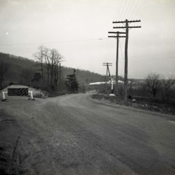
Photograph showing a portion of US Route 55 under construction.
This portion is located east of Strasburg Virginia near the foot of the Massanutten Mountain.
A sign straight ahead indicates with an arrow that traffic should use the old road…
This portion is located east of Strasburg Virginia near the foot of the Massanutten Mountain.
A sign straight ahead indicates with an arrow that traffic should use the old road…
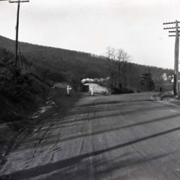
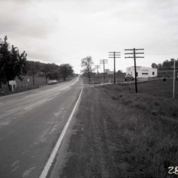
Route 55 East of Strasburg
Photograph showing a portion of US Route 55..
This portion is located east of Strasburg Virginia near the foot of the Massanutten Mountain. The road was later rerouted to avoid this crossing.
Telephone poles line both sides of the road.
This portion is located east of Strasburg Virginia near the foot of the Massanutten Mountain. The road was later rerouted to avoid this crossing.
Telephone poles line both sides of the road.
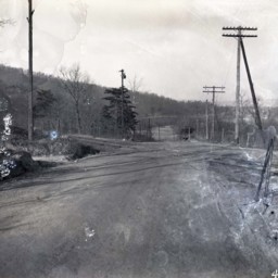
Route 55 East of Strasburg
Photograph showing a portion of US Route 55 under construction.
This portion is located east of Strasburg Virginia near the foot of the Massanutten Mountain.
A sign straight ahead indicates with an arrow that traffic should use the old road…
This portion is located east of Strasburg Virginia near the foot of the Massanutten Mountain.
A sign straight ahead indicates with an arrow that traffic should use the old road…
Route 42 West from Woodstock
View of Route 42 looking west from Woodstock.
Two farmhouses are visible on either side of the road. More houses are further down the road.
Today, there is a Starbucks located on the right..
Two farmhouses are visible on either side of the road. More houses are further down the road.
Today, there is a Starbucks located on the right..
Route 11 Near Pugh's Run

View of Route 11 looking south towards Woodstock at Pugh's Run.
Route 11 Heading Into Strasburg
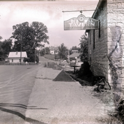
Photograph taken by the Old Mill Restaurant Building on Route 11 after it was paved and looking toward the town of Strasburg.
A small white house is visible on the left, while J.T. Golliday's Gulf Gas Station and two private residences further up…
A small white house is visible on the left, while J.T. Golliday's Gulf Gas Station and two private residences further up…
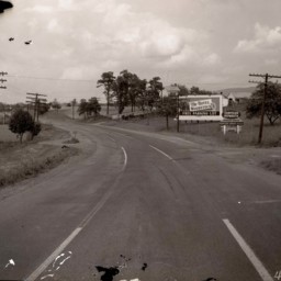
Route 11 Between Edinburg and Woodstock
View of Route 11 from south of Woodstock and looking south towards Edinburg.
A sign on the left advertises the Chrysler Plymouth business 2 miles ahead in Edinburg. A mailbox and turnout are visible on the right side of the road.
Debris from…
A sign on the left advertises the Chrysler Plymouth business 2 miles ahead in Edinburg. A mailbox and turnout are visible on the right side of the road.
Debris from…
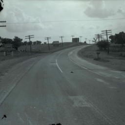
Route 11 Between Edinburg and Woodstock
View of Route 11 from north of Edinburg and looking north towards Woodstock.
Signs on the right side of the road advertise The Hotel Woodstock (3 miles) and the Woodstock Garage (4 miles).
Telephone poles line both sides of the road.
Signs on the right side of the road advertise The Hotel Woodstock (3 miles) and the Woodstock Garage (4 miles).
Telephone poles line both sides of the road.
Route 11 and Bowers Taxidermy
View looking south down U.S. Route 11 at the intersection with Saumsville Road north of Woodstock.
Bowers Taxidermy business, operated by Jimmy Bowers for more than 60 years, is visible on the right where "Deer Heads Mounted" is advertised on the…
Bowers Taxidermy business, operated by Jimmy Bowers for more than 60 years, is visible on the right where "Deer Heads Mounted" is advertised on the…
Roush Memorial Tombstone

Photograph taken by William Hoyle Garber showing the memorial stone erected to honor John Adam Rausch in New Market Virginia.
Round Image of a Young Man

Photo of a round portrait photograph of an unidentified young man.
Round Image of a Woman

Photo of an round image of an unidentified woman with glasses and her hair pulled back.
Round Image of a Man

Photo of a round portrait photograph of an unidentified man wearing a suit and tie with a starched collar.
Round Image of a Man

Photo of a portrait photograph of an unidentified man wearing a suit and bow tie.
The original image was cut into a round shape, probably to fit inside a frame.
The original image was cut into a round shape, probably to fit inside a frame.
Round Hill

Undated photograph showing "Round Hill"
Roulette (Clem) Smith and Daughter, Nell

Roulette (Clem) Smith, seated on a bench, with her daughter, Nell Smith, seated on her lap.
Roulette was married to Park Smith.
Roulette was married to Park Smith.
Rotted Steps
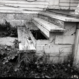
Photograph of dilapidated and rotted wooden porch steps.
Rotary Club Black-Face Show

Photograph taken by William Hoyle Garber showing a black-face minstrel performance sponsored by an unidentified Rotary Club.
Rotary Club Black-Face Show

Photograph taken by William Hoyle Garber showing a black-face minstrel performance sponsored by an unidentified Rotary Club.