

Browse Items (31227 total)
- Collection: Morrison Studio Collection
Sort by:
Wedding Photograph

Unidentified bride and groom, posed together. The bride is wearing a veil and gloves with her white dress.
Wedding Photograph

Photo of an older photograph showing an unidentified couple on their wedding day.
The original postcard is annotated at the bottom and was made by "Hebbel" at "409 N. Gay St." in "Baltimore, Maryland".
The original postcard is annotated at the bottom and was made by "Hebbel" at "409 N. Gay St." in "Baltimore, Maryland".
Wedding Photograph

Unidentified bride and groom posed together in their wedding clothes.
Wedding Portrait

Unidentified young couple in what appears to be their wedding apparel.
The bride is wearing a long white gown and a tulle hair covering. The groom is wearing a suit with a tie and vest.
The bride is wearing a long white gown and a tulle hair covering. The groom is wearing a suit with a tie and vest.
Wedding Sendoff
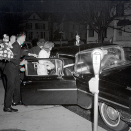
Photograph taken at night of unidentified well wishers ushering an unidentified new bride and groom into a car.
One man is holding a large flower arrangement that is waiting to be loaded into the back seat.
This photograph was taken on W.…
One man is holding a large flower arrangement that is waiting to be loaded into the back seat.
This photograph was taken on W.…
Weldon Ernest Hottle's Birth Certificate
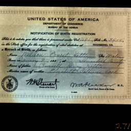
Photograph of the birth registration issued for Weldon Ernest Hottle who was born on January 9, 1928, in Shenandoah County.
Parents were Russell Henry Hottle and Elizabeth Catherine Cook.
Parents were Russell Henry Hottle and Elizabeth Catherine Cook.
Well-Dressed Toddler

Unidentified toddler seated on a wicker chair and wearing a dress and a bonnet tied in a big bow under her chin.
Welton Lee Webster's U.S. Navy Discharge
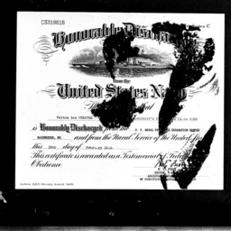
Photograph of the document certifying that Machinist's Mate Third class Welton Lee Webster was honorably discharged from the Navy in Bainbridge, Maryland, on February 18, 1946.
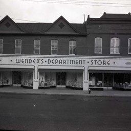
Wender's Department Store in Woodstock

Photograph of Wender's Clothing Store located at 103 S. Main Street in Woodstock, Virginia.
It was housed in the G.W. Koontz building.
Simon Z. Wender, the owner of Wender's, is visible on the left. The man on the right is unidentified.
It was housed in the G.W. Koontz building.
Simon Z. Wender, the owner of Wender's, is visible on the left. The man on the right is unidentified.
Wender's Department Store in Woodstock
Photograph of Wender's Department Store located on the corner of Court and Main Streets in Woodstock.
Wender's Department Store was a well-known fixture in the area until it closed in the early 1970's.
Formerly, the building was used to house…
Wender's Department Store was a well-known fixture in the area until it closed in the early 1970's.
Formerly, the building was used to house…
Wender's Department Store, Mount Jackson

Store front view of Wender's Department Store Mount Jackson, Virginia.
The Mount Jackson store was open from ca. 1920 until the late 1960s.
On the steps, Mr. Harry Howard, manager, is standing with his wife, daughter and a store clerk.
The Mount Jackson store was open from ca. 1920 until the late 1960s.
On the steps, Mr. Harry Howard, manager, is standing with his wife, daughter and a store clerk.
Wesley Glen Ritenour
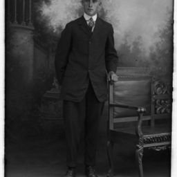
Photograph of Wesley Glenn Ritenour as a young man.
Wesley was from Fort Valley, the son of George Morgan Ritenour, a farmer, and Sarah Frances McInturff.
He married Isabel Inez Funk (1896-1978) when he was 21 years old.
As newlyweds,…
Wesley was from Fort Valley, the son of George Morgan Ritenour, a farmer, and Sarah Frances McInturff.
He married Isabel Inez Funk (1896-1978) when he was 21 years old.
As newlyweds,…
Wheat Field and Farm
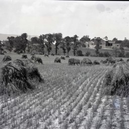
View across a wheat field that has been cut and put in piles awaiting further processing.
The picture shows the Clower farm located near Saumsville Virginia.
The house visible on the left still stands at 1292 Jadwyn Road and the house in the…
The picture shows the Clower farm located near Saumsville Virginia.
The house visible on the left still stands at 1292 Jadwyn Road and the house in the…
Whetzel and Cave Marriage Certificate

Photograph of a marriage certificate attesting that Charles A. Whetzel and Mary I. Cave were married in New Market, Virginia, on March 10, 1942.
Rev. M.L. Huffman, a minister of the Church of the Brethren, officiated.
Rev. M.L. Huffman, a minister of the Church of the Brethren, officiated.
White Dog

White dog with big ears is seated on a bench.
WHS Basketball Team
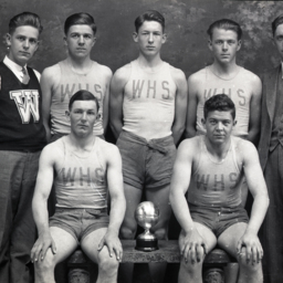
Unidentified members of Woodstock High School Basketball Team posed in two rows with a trophy in the center front. Each player has a shirt with, "WHS" on the front.
The coach is standing at the far right and the manager, whose sweater has an "M"…
The coach is standing at the far right and the manager, whose sweater has an "M"…
Wide-Eyed Baby

Unidentified baby posed on a wicker chair and wearing a long white gown.
Wide-Eyed Baby

Unidentified baby propped on a pillow with a locket around its neck, and an expression of wide-eyed surprise.
Wide-Eyed Toddler

Unidentified wide-eyed toddler seated on a pillowed bench.
Wide-Eyed Young Child

Unidentified young child is seated on a pillow and looking at the camera, wide-eyed.
Wilametta E. (Sibert) Copp

Photograph of Wilametta Elizabeth (Sibert) Copp as a young woman.
Born in Fort Valley, she was the daughter of Tressel E. and Elizabeth "Lizzie" (Burner) Sibert.
She married Fred P. Copp, Sr., and lived in Saumsville for much of her life.
Born in Fort Valley, she was the daughter of Tressel E. and Elizabeth "Lizzie" (Burner) Sibert.
She married Fred P. Copp, Sr., and lived in Saumsville for much of her life.
Wilbur and Barbara (Mauck) Dellinger
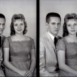
Photo of two separate photographs of Wilbur E. Dellinger and his wife, Barbara K. (Mauck) Dellinger.
Barbara was the daughter of Cecil Kedrick and Nora Kathryn (Kirby) Mauck. She was from Edinburg.
Wilbur Eugene Dellinger was the son of Clyde…
Barbara was the daughter of Cecil Kedrick and Nora Kathryn (Kirby) Mauck. She was from Edinburg.
Wilbur Eugene Dellinger was the son of Clyde…
Wilbur and Margaret (Burner) Riffey
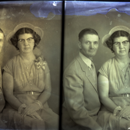
Photo of two separate photographs of Wilbur F. Riffey, a farmer, posed with his wife, Margaret E. (Burner) Riffey.
Both lived in Woodstock when they married in August 1953.
Wilbur is wearing a suit and patterned tie. Margaret is wearing a hat,…
Both lived in Woodstock when they married in August 1953.
Wilbur is wearing a suit and patterned tie. Margaret is wearing a hat,…
Wilbur Dellinger and Claudetta Dellinger
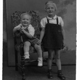
Siblings Wilbur and Claudetta Dellinger as children.
Their parents were Clyde Eugene Dellinger and Esther Frances Foltz, who lived on Senedo Road in Edinburg.
Their parents were Clyde Eugene Dellinger and Esther Frances Foltz, who lived on Senedo Road in Edinburg.
Wilbur Kingree
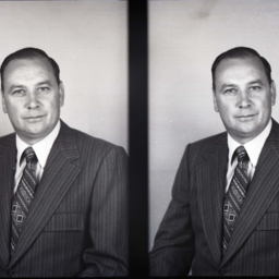
Photo of two portrait photographs of Wilbur Kingree wearing a striped suit and print tie.
The image on the left has a mark at the top where the photographer noted which of the two images he planned to print.
The image on the left has a mark at the top where the photographer noted which of the two images he planned to print.