

Browse Items (74 total)
Sort by:
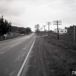
Route 11 Between Edinburg and Woodstock
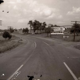
View of Route 11 from north of Edinburg and looking north towards Woodstock.
Signs on the right side of the road advertise The Hotel Woodstock (3 miles) and the Woodstock Garage (4 miles).
Telephone poles line both sides of the road.
Signs on the right side of the road advertise The Hotel Woodstock (3 miles) and the Woodstock Garage (4 miles).
Telephone poles line both sides of the road.
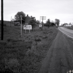
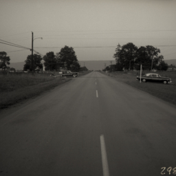
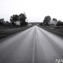
Rt 11 at Saumsville Road
View looking north on U.S. Route 11 near the intersection with Saumsville Road north of Woodstock.
The large brick home on the left side of the road (center of image) belonged to Jonathan Stribling Crabill.
A large white barn is on the…
The large brick home on the left side of the road (center of image) belonged to Jonathan Stribling Crabill.
A large white barn is on the…
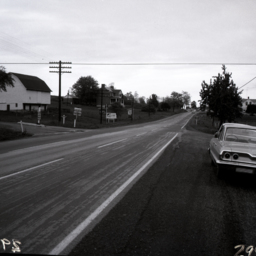
Rt 11 at Saumsville Road
View looking north on U.S. Route 11 near the intersection with Saumsville Road north of Woodstock.
Signs for the Alexander Hotel in Hagerstown, Shenandoah Apple Candy, and the Clearbrook Woolen Shop are also visible on the left side of the…
Signs for the Alexander Hotel in Hagerstown, Shenandoah Apple Candy, and the Clearbrook Woolen Shop are also visible on the left side of the…
Senedo Road and Hisey Avenue - Woodstock Virginia
Photograph showing Route 42 on the western edge of Woodstock.
The photograph looks west away from Woodstock. It was taken close to the intersection of what, in 2025, is Woodstock Commons Drive and Reservoir Road.
The house on the right still…
The photograph looks west away from Woodstock. It was taken close to the intersection of what, in 2025, is Woodstock Commons Drive and Reservoir Road.
The house on the right still…
Senedo Road and Hisey Avenue - Woodstock Virginia
Photograph showing Route 42 on the western edge of Woodstock Virginia.
The photograph looks east toward Woodstock. It was taken at the intersection of what is now Reservoir Road and Hisey Avenue.
Two automobiles are also visible.
The photograph looks east toward Woodstock. It was taken at the intersection of what is now Reservoir Road and Hisey Avenue.
Two automobiles are also visible.
Scenic View
View of Massanutten Mountain from a country road somewhere west of it.
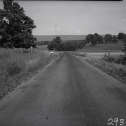
Scenic View
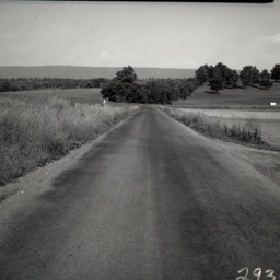
View of Massanutten Mountain from a country road somewhere west of it.
Scenic View
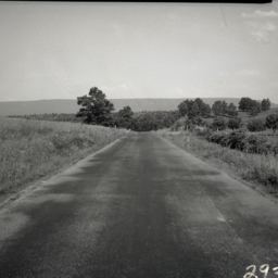
View looking east from a country road somewhere west of Massanutten Mountain.
Road View
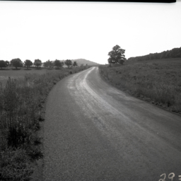
Scenic view along a country road in Shenandoah County, Virginia. Fields and a hill are visible in the background.
The photograph was taken in the area of 3398 Ridge Road north east of New Market Virginia.
The photograph was taken in the area of 3398 Ridge Road north east of New Market Virginia.
Three Vintage Airplanes
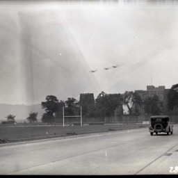
View of three vintage bi-planes flying over unidentified stone buildings and beyond an athletic field.
A road and early automobile are on the right side of the image.
A road and early automobile are on the right side of the image.
Alley in Woodstock
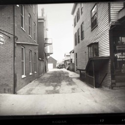
View down the alley between the Woodstock Hotel and the Pure Food Store. A vintage automobile is visible at the end of the alley.
As of 2025, the alley is between the former Walton and Smoot Pharmacy building (now empty) and the Woodstock Cafe.
As of 2025, the alley is between the former Walton and Smoot Pharmacy building (now empty) and the Woodstock Cafe.
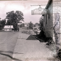
Route 11 and Bowers Taxidermy
View looking south down U.S. Route 11 at the intersection with Saumsville Road north of Woodstock.
Bowers Taxidermy business, operated by Jimmy Bowers for more than 60 years, is visible on the right where "Deer Heads Mounted" is advertised on the…
Bowers Taxidermy business, operated by Jimmy Bowers for more than 60 years, is visible on the right where "Deer Heads Mounted" is advertised on the…
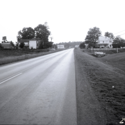
Route 42 West from Woodstock
View of Route 42 looking west from Woodstock.
Two farmhouses are visible on either side of the road. More houses are further down the road.
Today, there is a Starbucks located on the right..
Two farmhouses are visible on either side of the road. More houses are further down the road.
Today, there is a Starbucks located on the right..
Road Work
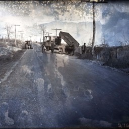
Early dump truck is unloading a load of dirt at the side of a road. Unidentified workmen are on hand. An early road roller is also visible on the left.
Possibly, this photograph was taken during the work to pave Route 11.
Possibly, this photograph was taken during the work to pave Route 11.
Road Work - Route 11
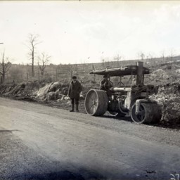
Photograph of an unidentified man in an early road roller machine, Another unidentified man is standing beside the roller.
This photograph was taken on US Route 11 just North of the Narrow Passage Bridge south of Woodstock.
This photograph was taken on US Route 11 just North of the Narrow Passage Bridge south of Woodstock.
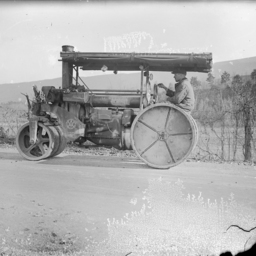
Road Work - Route 11

Photograph of an unidentified man driving an early road roller with another unidentified man standing beside the machine.
A label on the side of the machine says, "The Austin Western Line Serves You Right".
Austin-Western was a well-known…
A label on the side of the machine says, "The Austin Western Line Serves You Right".
Austin-Western was a well-known…
Road Work - Route 11
Photograph of an unidentified man driving an early road roller.
This photograph was taken on US Route 11 just North of the Narrow Passage Bridge south of Woodstock.
A label on the side of the machine says, "The Austin Western Line Serves You…
This photograph was taken on US Route 11 just North of the Narrow Passage Bridge south of Woodstock.
A label on the side of the machine says, "The Austin Western Line Serves You…
Route 11 Heading Into Strasburg
Photograph taken by the Old Mill Restaurant Building on Route 11 after it was paved and looking toward the town of Strasburg.
A small white house is visible on the left, while J.T. Golliday's Gulf Gas Station and two private residences further up…
A small white house is visible on the left, while J.T. Golliday's Gulf Gas Station and two private residences further up…
House in Rural Setting

Unidentified two-story farmhouse with a chimney and metal roof is located close to a dirt road. The site is surrounded by mountains and forest.
Rural View

View of a county road heading down a narrow valley.
A 1920's era automobile is visible on the road and a house is on the right. Mountains are also visible.
A 1920's era automobile is visible on the road and a house is on the right. Mountains are also visible.
Rural Dirt Road and Trees

Unidentified rural scene with a small wooden bridge, dirt road, trees, and a few unidentified buildings or picnic pavilions in the background.
Road Along A River

Photograph of a dirt road located above and along a stretch of river.
An unidentified man is standing at the base of the telephone pole. A house and power lines are also visible.
An unidentified man is standing at the base of the telephone pole. A house and power lines are also visible.
Hairpin Curve on Orkney Springs Grade

Photograph of a switchback on Orkney Grade, a road connecting Mount Jackson, Virginia, with the communities of Orkney Springs and Basye, Virginia.
This photograph shows the area commonly known as the "Double S Curves," where two switchback curves…
This photograph shows the area commonly known as the "Double S Curves," where two switchback curves…
Road and Mountains

Unidentified road leading towards a tree-covered mountain. A wood fence is visible in the foreground.
Burner Farm

Photograph of the Burner Farm, located southwest of Luray Virginia.
A 1920s era automobile is on the road and a house and barn are visible in the distance.
A 1920s era automobile is on the road and a house and barn are visible in the distance.