

Browse Items (45 total)
Sort by:
Main Street, New Market
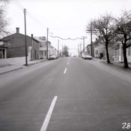
View looking south on Main Street (U.S. Route 11) in New Market, Virginia.
The photograph was taken in winter. Houses, buildings, and vehicles are visible on both sides of the street.
The photograph was taken in winter. Houses, buildings, and vehicles are visible on both sides of the street.
Old Mill Tavern and View Looking South
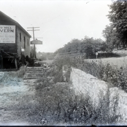
Photograph taken in the overgrown parking lot of the Old Mill Tavern (located in the historic Spengler's Mill) on the southern edge of Strasburg and looking southwards down Route 11. The building is still there today.
The water-powered mill was…
The water-powered mill was…
Route 11 Heading Into Strasburg
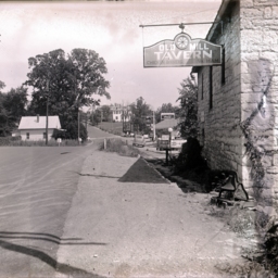
Photograph taken by the Old Mill Restaurant Building on Route 11 after it was paved and looking toward the town of Strasburg.
A small white house is visible on the left, while J.T. Golliday's Gulf Gas Station and two private residences further up…
A small white house is visible on the left, while J.T. Golliday's Gulf Gas Station and two private residences further up…
Corner of Main and High Streets, Woodstock

Photograph of the intersection of Main Street (US Route 11) and High Street in Woodstock Virginia.
The photograph looks west from the area of what in 2025 was the Farmer's and Merchants Bank. An empty lot, several houses, and the Woodstock…
The photograph looks west from the area of what in 2025 was the Farmer's and Merchants Bank. An empty lot, several houses, and the Woodstock…
US Route 11 Near Strasburg

View of US Route 11 (formerly the Valley Turnpike) just south of Strasburg on Fishers Hill.
Unidentified men and a 1920's era automobile are visible.
This photograph was used in John Wayland's book, "A History of Shenandoah County, Virginia",…
Unidentified men and a 1920's era automobile are visible.
This photograph was used in John Wayland's book, "A History of Shenandoah County, Virginia",…
Valley Turnpike Near Fishers Hill

View of the unpaved Valley Turnpike (now US Route 11) taken from just south of the town of Strasburg near Fishers Hill.
The small bridge is crossing Tumbling Run, a creek that empties into the North Fork of the Shenandoah River near this spot.
The small bridge is crossing Tumbling Run, a creek that empties into the North Fork of the Shenandoah River near this spot.
Tollgate in Woodstock

View of a tollgate raised on the Valley Turnpike at the northern end of Woodstock, Virginia.
It was located at 409 North Main Street, Woodstock, Virginia.
There is an unidentified woman collecting a toll from the driver of an early automobile.…
It was located at 409 North Main Street, Woodstock, Virginia.
There is an unidentified woman collecting a toll from the driver of an early automobile.…
View along the Valley Turnpike

Photograph of the view along the Valley Turnpike (now US Route 11) just North of New Market Virginia.
The roadway is visible center left of the image as is the 54th Pennsylvania Volunteer Infantry monument present on the New Market battlefield…
The roadway is visible center left of the image as is the 54th Pennsylvania Volunteer Infantry monument present on the New Market battlefield…
C.M. Shannon House

Photograph of the C.M. Shannon House located on Route 11 at Shannon Avenue in Mount Jackson, across from the Dellinger Funeral Home.
Lee-Jackson Hotel, New Market VA

Postcard showing the Lee-Jackson Hotel on the corner of US Highway Number 11 and Number 211 in New Market Virginia.
View East from Woodstock VA, showing Massanutten Mountain and New York to Atlanta National Highway

Postcard showing the Massanutten Mountain and Route 11 from Woodstock Virginia.
MD's

Postcard advertising M.D's Modern cabins located 1 1/2 miles north of New Market Virginia
"Meem's Bottom" on Route 11 along the Scenic Shenandoah Valley, Va.

Postcard showing US Route 11 passing through "Meem's Bottom."
The view looks north from the area of Rude's Hill, a geographic feature located between Mt. Jackson and New Market. The house and barn on the left of the image still stand (as of 2023)…
The view looks north from the area of Rude's Hill, a geographic feature located between Mt. Jackson and New Market. The house and barn on the left of the image still stand (as of 2023)…
View East from Woodstock, Va. showing Massanutten Mountain, N.Y. to Atlanta National Highway

Postcard showing an image a view of US Highway 11 and the Massanutten Mountain. The picture looks east from a point between Woodstock and Edinburg.
View from Fishers Hill Battleground, showing Bridge over Tumbling Run on National Highway

Color postcard showing a picture of the Valley Pike (Route 11) bridge that crosses Tumbling Run near the Fishers Hill Battlefield.
The Picturesque Shenandoah River with Fishers Hill Battle Ground in the Distance, near Strasburg Va.

Postcard with an image of the Shenandoah River and US Highway 11 near Fishers Hill.
The view looks north toward Strasburg Virginia. The card was produced in 1911.
The view looks north toward Strasburg Virginia. The card was produced in 1911.
Fisher Hill on Rte. 11, Shenandoah Valley, Va.

Color postcard with a picture of US Route 11 at Fishers Hill and the interpretative highway sign describing the Civil War Battle that occurred there. The image is looking south from the top of the hill toward Strasburg.
Fisher's Hill Battlefields and Valley Turnpike, Strasburg VA

Postcard with a photograph showing a view of Fishers Hill and the Valley Turnpike (US Route 11).
The postcard is undated.
The postcard is undated.
Famous Valley Pike, The National Highway, Strasburg, Va.

Postcard with a picture of the Valley Pike (now US Route 11) beside a body of water near Strasburg Virginia. The body of water is possibly the Shenandoah River.
Cedar Creek Bridge on Valley Pike near Strasburg, Va.

Postcard with a colorized image of Cedar Creek and the bridge that spans it on the Shenandoah County/Frederick County boundary north of Strasburg Virginia.
The postcard is dated 1915.
The postcard is dated 1915.