

Browse Items (54 total)
Sort by:
"War Views"

Photographic card bearing an image of a steam locomotive and cars on the Narrow Passage Railroad Trestle located between Edinburg and Woodstock Virginia.
The reverse bears an advertisement for "War Views," images of various Civil War sites in…
The reverse bears an advertisement for "War Views," images of various Civil War sites in…
Signal Knob, Near Strasburg, Virginia
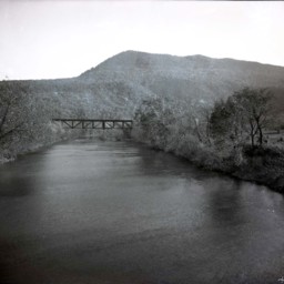
Photograph of the Shenandoah River, railroad bridge. and Massanutten Mountain's Signal Knob near Strasburg Virginia.
The photograph was taken from the Route 55 Highway bridge just east of Strasburg.
The railroad bridge runs close to the…
The photograph was taken from the Route 55 Highway bridge just east of Strasburg.
The railroad bridge runs close to the…
Bridge at Burnshire Dam
Photograph of the bridge spanning the Shenandoah River northwest of Woodstock Virginia. Behind it is Burnshire Dam and the mountains.
Originally, this site was home to Rush's Mill. In 1873 it was purchased by J.I. Triplett. In 1892 he converted…
Originally, this site was home to Rush's Mill. In 1873 it was purchased by J.I. Triplett. In 1892 he converted…
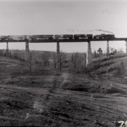
Train Crossing at Narrow Passage Creek

Photograph of a steam powered, passenger train crossing the viaduct over Narrow Passage Creek.
Steam from the engine is visible along the length of the train and light is shining through rail car windows.
Steam from the engine is visible along the length of the train and light is shining through rail car windows.
Men Working By a Railroad Bridge
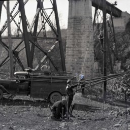
Photograph of four unidentified men working beside an unidentified railroad bridge. A fifth man is sitting in the truck.
It appears they are working to install a steel cable and one of the men is on a telephone pole. The vintage truck on the left…
It appears they are working to install a steel cable and one of the men is on a telephone pole. The vintage truck on the left…
Men Working By a Railroad Bridge
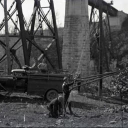
Photograph of four unidentified men working beside an unidentified railroad bridge. A fifth man is sitting in the truck.
It appears they are working to install a steel cable and one of the men is on a telephone pole. The vintage truck on the left…
It appears they are working to install a steel cable and one of the men is on a telephone pole. The vintage truck on the left…
Narrow Passage Railroad Bridge
Photograph of a train crossing the Narrow Passage Railroad Bridge.
As of 2025, the bridge still stands and is unused.
As of 2025, the bridge still stands and is unused.
"Dinky" Railroad Wreck
Photograph of an earlier photograph showing the wreck of a locomotive and railcars on a trestle of the "Dinky" Railroad near Edinburg Virginia.
The "Dinky" Railroad connected Edinburg Virginia with the iron operations at Liberty Furnace. This…
The "Dinky" Railroad connected Edinburg Virginia with the iron operations at Liberty Furnace. This…
Covered Bridge at Timberville

Photograph of the covered bridge spanning the North Fork of the Shenandoah River in Timberville Virginia.
This photograph looks north and the road pictured is today Main Street (Route 42).
A sign above the entrance to the bridge reads,…
This photograph looks north and the road pictured is today Main Street (Route 42).
A sign above the entrance to the bridge reads,…
View of Railroad Bridge Over Pugh's Run

View of the covered railroad bridge over Pugh's Run, about two miles north of Woodstock. The photograph was taken looking west from Old Valley Pike (Route 11).
Young Woman on Foot Bridge

Unidentified woman with short hair and wearing a sailor-themed shirt is standing at the entrance to a pedestrian bridge.
Short, Steep Bridge

Photo of a photograph showing an unidentified bridge across a small creek or wet area.
The shape of the bridge is unusually short and steep.
Terrain behind the bridge is flat.
The shape of the bridge is unusually short and steep.
Terrain behind the bridge is flat.
Vann Railroad Trestle - "Dinky Railroad"

Photo of a photograph of a railroad trestle on what is commonly called the "Dinky" Railroad which connected Edinburg Virginia to Liberty Iron Furnace in western Shenandoah County.
This is known as the Vann Trestle and it stood just west of the…
This is known as the Vann Trestle and it stood just west of the…
Covered Bridge

Photograph of an unidentified covered bridge over a dry stone riverbed.
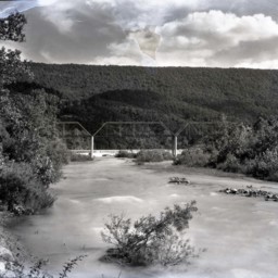
Railroad Bridge and Signal Knob, Near Strasburg

Photograph of the Shenandoah River, railroad bridge. and Massanutten Mountain's Signal Knob near Strasburg Virginia.
The photograph was taken from the Route 55 Highway bridge just east of Strasburg.
The photograph was taken from the Route 55 Highway bridge just east of Strasburg.
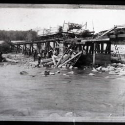
Railroad Bridge Construction

Photograph showing a crane mounted on a railcar working on the railroad trestle crossing Toms Brook in the town of Toms Brook Virginia.
This photograph was taken in the spring of 1924 when the Southern Railway Company installed a new bridge at…
This photograph was taken in the spring of 1924 when the Southern Railway Company installed a new bridge at…
Edinburg Railroad Bridge Fire

Photograph showing the railroad bridge crossing Stony Creek in Edinburg after it was destroyed by a fire.
The photograph is undated, but the fire occurred on August 2, 1915.
The photograph is undated, but the fire occurred on August 2, 1915.
Bridge over "Hawksbill" Luray Va.

Postcard showing the bridge of Hawksbill Creek in Luray Virginia
Brock's Gap, Va.

Postcard showing Brock's Gap in Rockigham County Virginia and a Railroad Bridge
Bridge Crossing North Fork Shenandoah River, Between New Market and Depot

Postcard showing an iron bridge crossing the North Fork of the Shenandoah River.
The bridge was located on what is now called New Market Depot Road which connected the town of New Market Virginia to the New Market Depot on the nearby rail line.…
The bridge was located on what is now called New Market Depot Road which connected the town of New Market Virginia to the New Market Depot on the nearby rail line.…
North Fork of the Shenandoah River and Iron Bridge, erected 1892, west of New Market Va.

Postcard showing the iron bridge over the Shenandoah River west of New Market Virginia
Scene on Shenandoah River, near New Market, Va.

Postcard showing the Shenandoah River and Iron Bridge west of New Market Virginia
Quaint Covered Bridge

Postcard showing the "Quaint Covered Bridge" crossing the North Fork of the Shenandoah River near Mt. Jackson Virginia.
This bridge, commonly known as the "Meems Bottom" Bridge, is the last remaining in Shenandoah County still in use.
This bridge, commonly known as the "Meems Bottom" Bridge, is the last remaining in Shenandoah County still in use.
Old Covered Bridge on the Beautiful Shenandoah Rive at Meems Bottom, Va.

Postcard showing the covered bridge at Meems Bottom near Mt. Jackson Virginia