
Browse Items (33937 total)
Sort by:
Sky Chalet

Postcard showing a view from Sky Chalet.
Sky Chalet is a lodge/bed and breakfast facility located on Supinlick Ridge in the Basye community.
At the time this postcard was published it had a Macanie post office address.
Sky Chalet is a lodge/bed and breakfast facility located on Supinlick Ridge in the Basye community.
At the time this postcard was published it had a Macanie post office address.
Sky Chalet

Postcard showing the Sky Chalet resort located near Basye Virginia.
Sky Chalet was originally constructed in 1937. This 1945 postcard shows the rear of the building with its unique overlook.
The postcard title is labeled "Macanie" because at…
Sky Chalet was originally constructed in 1937. This 1945 postcard shows the rear of the building with its unique overlook.
The postcard title is labeled "Macanie" because at…
Stop and Look Store and Post Office

Postcard showing the "Stop and Look" store and post office located in Basye Virginia
Mountain View from Supin Lick-Bryce's Hillside Cottages

Photographic postcard showing a view of mountains in the Basye Community of Shenandoah County. The photograph was taken from "Supin Lick" or Supinlick Ridge which forms the western part of the valley that community lies in and which Bryce's Hillside…
Greystone Lodge

Postcard showing the Greystone Lodge in Basye Virginia.
This structure was originally constructed by Vice Admiral Henry V. Butler ca. 1920. It was operated as a type of hunting/recreation lodge around 1950. Today it is a private residence.
This structure was originally constructed by Vice Admiral Henry V. Butler ca. 1920. It was operated as a type of hunting/recreation lodge around 1950. Today it is a private residence.
Greystone Lodge, Basye, VA.

Postcard with an image of the "Greystone Lodge" located near Basye Virginia in western Shenandoah County.
Quicksburg Depot
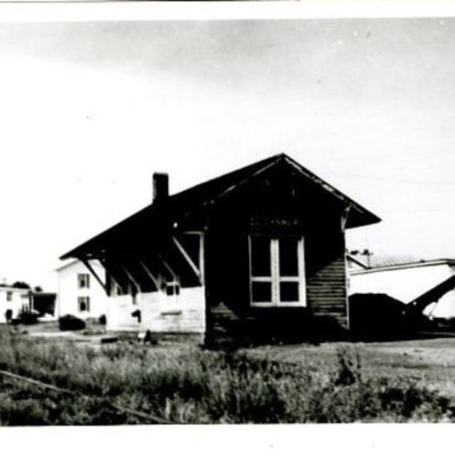
Postcard with a photograph showing the railroad depot in Quicksburg Virginia.
The postcard is undated.
The depot was removed from its original location and moved to private property where is still stands.
The postcard is undated.
The depot was removed from its original location and moved to private property where is still stands.
Tuttle & Spice 1880 General Store

Postcard showing the Tuttle & Spice General Store that operated near Interstate 81's Exit 269, Shenandoah Caverns, in Shenandoah County.
Shenandoah Caverns Inn

Postcard showing the Inn at Shenandoah Caverns located near Mt. Jackson Virginia.
Shenandoah Valley Pike, North of New Market Va.

Postcard with an image of the "Shenandoah Valley Pike" (US Highway 11) between New Market and Mt. Jackson Virginia.
Shenandoah Valley Pike, looking North, New Market, Va.

Postcard bearing an image of the "Shenandoah Valley Pike" looking north. What was then the Valley Turnpike is now US Route 11.
In the background of the image is "the Knob," a protected feature located on the southwest end of the Short Mountain,…
In the background of the image is "the Knob," a protected feature located on the southwest end of the Short Mountain,…
B.E. Nelson Wheat Field

Postcard showing B.E. Nelson's wheat field.
The Knob, Mt. Jackson VA

Postcard showing a view of "The Knob."
"The Knob" is a geographic feature on the Massanutten Mountain just east of the town of Mt. Jackson Virginia. It is called "Short Mountain."
"The Knob" is a geographic feature on the Massanutten Mountain just east of the town of Mt. Jackson Virginia. It is called "Short Mountain."
Seeding on Meems Bottom (Strathmore)

Postcard showing a crew of men with a team of horses and mules seeding farmland.
The card's caption identifies the farm as "Mount Airy (Strathmore)" which is located south of the Town of Mount Jackson along what is now US Route 11 and the North…
The card's caption identifies the farm as "Mount Airy (Strathmore)" which is located south of the Town of Mount Jackson along what is now US Route 11 and the North…
Driveway from Valley Pike to Mt. Airy

Photographic postcard showing the driveway leading to "Mt. Airy" a farm along the Shenandoah River in the Meems Bottom area just south of Mt. Jackson Virginia.
The image also shows the Massanutten Mountain in the background and was taken near…
The image also shows the Massanutten Mountain in the background and was taken near…
S.P. Lonas' Mills Dam, Mt. Jackson Va.

Postcard showing the "S.P. Lonas' Mill Dam" in Mt. Jackson Virginia.
The dam was located on Mill Creek on what is now the southern part of town. It was constructed sometime before 1897.
The dam was located on Mill Creek on what is now the southern part of town. It was constructed sometime before 1897.
Unidentified House

Postcard showing a house somewhere in Shenandoah County.
The postcard was sent from Moore's Store and the structure may be in that community.
The postcard was sent from Moore's Store and the structure may be in that community.
Partial View of Moonlight Cottage Camp, Mt. Jackson VA

Postcard showing a partial view of the Moonlight Cottage Camp.
The camp, which included cottages for visitors and a dining room, was located north of the Town of Mt. Jackson near the current Bowman-Andros manufacturing plant.
The camp, which included cottages for visitors and a dining room, was located north of the Town of Mt. Jackson near the current Bowman-Andros manufacturing plant.
Partial View of Moonlight Cottage Camp, Mt. Jackson Va.

Postcard showing a partial view of the "Moonlight Cottage Camp."
This motel/tourist camp was located near Mt. Jackson Virginia. It opened sometime around 1928. The original owners were Emma and Verlin Proctor. The business consisted of eight…
This motel/tourist camp was located near Mt. Jackson Virginia. It opened sometime around 1928. The original owners were Emma and Verlin Proctor. The business consisted of eight…
Shenstone House

Postcard showing the "Shenstone" House in the southern end of Mt. Jackson. The roof of the covered bridge crossing Mill Creek is visible in the bottom of the photograph.
Residence of S.P. Lonas Mt. Jackson Va.

Postcard showing the home of S.P. Lonas of Mt. Jackson Virginia. The image is dated 1929.
Today, the structure houses Dellinger Funeral Home.
Today, the structure houses Dellinger Funeral Home.
B Street Looking East, Showing Shenandoah River Bridge

Postcard showing "B Street" in Mt. Jackson Virginia and the bridge over the North Fork of the Shenandoah River. It is dated 1915.
Today this street is named Bridge Street and dead ends at the former site of the river bridge.
Today this street is named Bridge Street and dead ends at the former site of the river bridge.
Main Street, Looking North, Mt. Jackson VA

Postcard showing a picture of Main Street in Mt. Jackson Virginia. The photograph is oriented north and was taken in the area of what is now King and Main Streets.
Main Street, looking South, Mt. Jackson Va.

A photographic postcard showing Main Street in Mt. Jackson Virginia. The card is dated 1911 and indicates it is looking south.
Main Street, Looking South, Mt. Jackson VA

Postcard with a picture showing Main Street and surrounding houses in Mt. Jackson looking south.