

Browse Items (35719 total)
Sort by:
Endless Cavern Formations
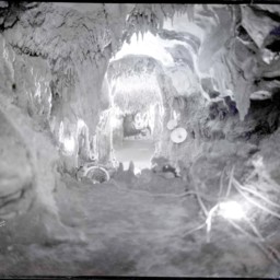
Photograph of rock formations inside Endless Cavern.
Stonewall Mill Dam on Shenandoah River, Virginia
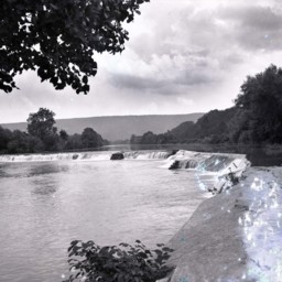
Photograph of Stonewall Dam near Pugh's Run.
This dam was part of the Stonewall Mill complex. The original mill dates to before the Civil War, but this dam was most likely constructed around the turn of the 20th century when the site began…
This dam was part of the Stonewall Mill complex. The original mill dates to before the Civil War, but this dam was most likely constructed around the turn of the 20th century when the site began…
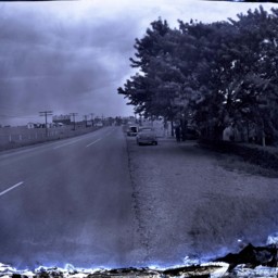
Route 55 East of Strasburg
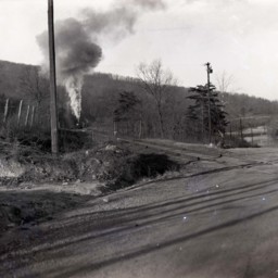
Photograph showing a portion of US Route 55.
This portion is located east of Strasburg Virginia near the foot of the Massanutten Mountain. The road was later rerouted to avoid the railroad crossing pictured here.
A steam engine is headed…
This portion is located east of Strasburg Virginia near the foot of the Massanutten Mountain. The road was later rerouted to avoid the railroad crossing pictured here.
A steam engine is headed…
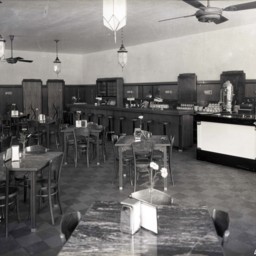
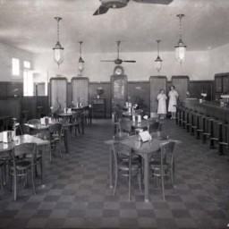
Inside the Virginia Restaurant in Strasburg
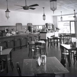
View of the interior of the Virginia Restaurant located on the corner of King and Holliday Streets in Strasburg. The restaurant was a favorite meeting place for students after school and evenings.
Behind the long counter, stand two longtime…
Behind the long counter, stand two longtime…
Inside the Virginia Restaurant in Strasburg
View of the interior of the Virginia Restaurant located on the corner of King and Holliday Streets in Strasburg. The restaurant was a favorite meeting place for students after school and evenings.
Tables and a long sandwich bar along the right…
Tables and a long sandwich bar along the right…
View Along Route 11 North of Strasburg
View looking north along Route 11 just north of Strasburg, Virginia.
Vintage automobiles are parked on the right side of the road. A historical marker stands between the two cars and is titled, "Fort Bowman".
An Esso station advertising cabins,…
Vintage automobiles are parked on the right side of the road. A historical marker stands between the two cars and is titled, "Fort Bowman".
An Esso station advertising cabins,…
Men Repaving King Street in Strasburg
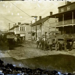
Damaged image of unidentified men with shovels digging up King Street in Strasburg in preparation for its repaving.
Early trucks are seen with the men. The truck on the right of the image has a sign on the side that reads, "Virginia Department of…
Early trucks are seen with the men. The truck on the right of the image has a sign on the side that reads, "Virginia Department of…
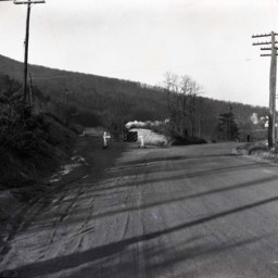
Route 55 East of Strasburg

Photograph showing a portion of US Route 55 under construction.
This portion is located east of Strasburg Virginia near the foot of the Massanutten Mountain.
A sign straight ahead indicates with an arrow that traffic should use the old road…
This portion is located east of Strasburg Virginia near the foot of the Massanutten Mountain.
A sign straight ahead indicates with an arrow that traffic should use the old road…
Jakes Fountain Service
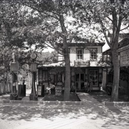
Photograph of Jakes Fountain Service and service station in Orkney Springs, Virginia.
Unidentified people are seated on the front porch enjoying two large shade trees in the small yard.
Two gas pumps featuring Atlantic Gasoline are on the…
Unidentified people are seated on the front porch enjoying two large shade trees in the small yard.
Two gas pumps featuring Atlantic Gasoline are on the…
View Along King Street in Strasburg
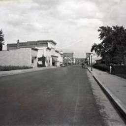
View looking east along King Street (Route 11) in Strasburg, Virginia.
First Bank is visible on the left as is the Virginia Restaurant across Holliday Street.
Vintage automobiles are parked on both sides of the street.
This photograph was…
First Bank is visible on the left as is the Virginia Restaurant across Holliday Street.
Vintage automobiles are parked on both sides of the street.
This photograph was…
Strasburg Service Station
Photograph of the Strasburg Service Station that was located on the corner of W. King and Capon Streets in Strasburg.
The service station opened in 1922 and was a well-known fixture in the town.
The service station opened in 1922 and was a well-known fixture in the town.
Inside the Virginia Restaurant in Strasburg
View of the interior of the Virginia Restaurant located on the corner of King and Holliday Streets in Strasburg. The restaurant was a favorite meeting place for students after school and evenings.
At the back of the room, stand two longtime…
At the back of the room, stand two longtime…
First National Bank in Strasburg
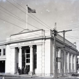
Photograph taken during construction (ca 1929) of the First National Bank located on the corner of King and Holliday Streets in Strasburg.
Four unidentified men in suits and hats are standing in front of the door. An early automobile is parked on…
Four unidentified men in suits and hats are standing in front of the door. An early automobile is parked on…
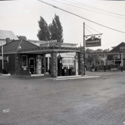
Strasburg Service Station
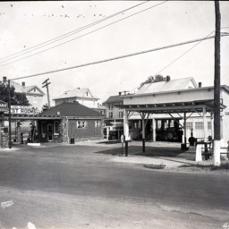
Photograph of the Strasburg Service Station that was located on the corner of W. King and Capon Streets in Strasburg.
A sign on the building on the right reads, "Car Laundry", and a covered pavilion stands in front of it near the sidewalk.
The…
A sign on the building on the right reads, "Car Laundry", and a covered pavilion stands in front of it near the sidewalk.
The…
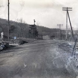
Route 55 East of Strasburg
Photograph showing a portion of US Route 55 under construction.
This portion is located east of Strasburg Virginia near the foot of the Massanutten Mountain.
A sign straight ahead indicates with an arrow that traffic should use the old road…
This portion is located east of Strasburg Virginia near the foot of the Massanutten Mountain.
A sign straight ahead indicates with an arrow that traffic should use the old road…
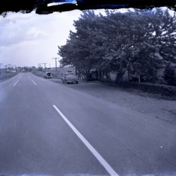
Route 55 East of Strasburg
Photograph showing a portion of US Route 55..
This portion is located east of Strasburg Virginia near the foot of the Massanutten Mountain. The road was later rerouted to avoid this crossing.
Telephone poles line both sides of the road.
This portion is located east of Strasburg Virginia near the foot of the Massanutten Mountain. The road was later rerouted to avoid this crossing.
Telephone poles line both sides of the road.
View Along Route 11 North of Strasburg
View looking north along Route 11 just north of Strasburg, Virginia.
Vintage automobiles are parked on the right side of the road. A historical marker stands between the two cars and is titled, "Fort Bowman".
An unidentified man holding his hat…
Vintage automobiles are parked on the right side of the road. A historical marker stands between the two cars and is titled, "Fort Bowman".
An unidentified man holding his hat…
Strasburg Water Tower
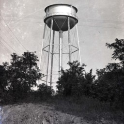
Photograph of the water tower located on top of Fort Hill in Strasburg, Virginia.
It is still used as a water reservoir.
It is still used as a water reservoir.
Lot on N. Fort Street, Strasburg
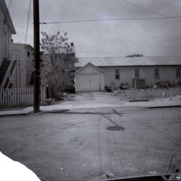
Photograph of an empty lot, a long metal-roofed, building, a detached garage, and the back of buildings.
The buildings on the left front on King Street, Strasburg. This photograph was taken from just off King Street on N. Fort Street in…
The buildings on the left front on King Street, Strasburg. This photograph was taken from just off King Street on N. Fort Street in…
View of Signal Knob Mountain Near Strasburg
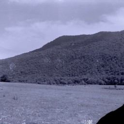
View of Signal Knob Mountain located in Strasburg, Virginia.
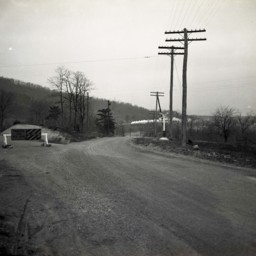
Route 55 East of Strasburg
Photograph showing a portion of US Route 55 under construction.
This portion is located east of Strasburg Virginia near the foot of the Massanutten Mountain.
A sign straight ahead indicates with an arrow that traffic should use the old road…
This portion is located east of Strasburg Virginia near the foot of the Massanutten Mountain.
A sign straight ahead indicates with an arrow that traffic should use the old road…
Strasburg Water Tower and House
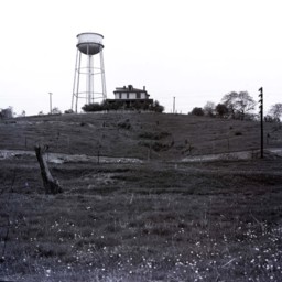
Photograph looking up Fort Hill towards the Strasburg Water Tower and a two-story home beside it.
Possibly, this photograph was taken from behind the Strasburg United Methodist Church on West Washington Street.
Possibly, this photograph was taken from behind the Strasburg United Methodist Church on West Washington Street.
Signal Knob, Near Strasburg, Virginia
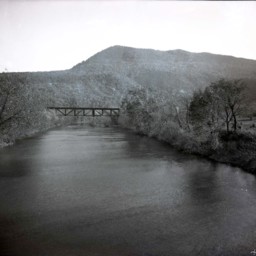
Photograph of the Shenandoah River, railroad bridge. and Massanutten Mountain's Signal Knob near Strasburg Virginia.
The photograph was taken from the Route 55 Highway bridge just east of Strasburg.
The railroad bridge runs close to the…
The photograph was taken from the Route 55 Highway bridge just east of Strasburg.
The railroad bridge runs close to the…
Stonewall Mill Dam on Shenandoah River, Virginia
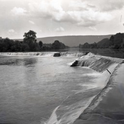
Photograph of Stonewall Dam near Pugh's Run.
This dam was part of the Stonewall Mill complex. The original mill dates to before the Civil War, but this dam was most likely constructed around the turn of the 20th century when the site began…
This dam was part of the Stonewall Mill complex. The original mill dates to before the Civil War, but this dam was most likely constructed around the turn of the 20th century when the site began…
1936 Toms Brook High School Seniors
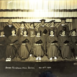
Group of unidentified students posed together in two rows on a stage, all wearing their graduation caps and gowns and holding their diplomas.
An unidentified adult, probably a teacher or principal, is standing at the far left.
The photographer…
An unidentified adult, probably a teacher or principal, is standing at the far left.
The photographer…